Drone Program Combines Images, Video for 3D Sitemap
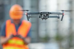
DroneDeploy, a cloud software company, is using drone footage to help get bird’s-eye views of construction sites and build a 3D picture of the area. This week, the company announced a new initiative alongside Boston Dynamics, "360 Walkthrough," that combines drone photos with cameras on the ground, or even ground robots.
360 Walkthrough can capture and process photos, videos, and more from any angle—"from the ground to the air, from exterior to interior, on foot or by machine," Tech Crunch reports. The software works with both drones/aerial cameras and any on-the-ground 360-cameras to provide a digital reconstruction of any job site.
As part of its testing phase, "DroneDeploy retrofitted Boston Dynamics' Spot robot with a 360-degree camera to autonomously capture data from inside buildings and snap close-up photos for anyone to inspect remotely. Anyone watching the footage can identify issues on-site, such as a crack that has appeared in a newly built wall," according to Venture Beat.
“Our customers are looking to get data from the interiors, and they’re looking for one digital twin, one digital reconstruction of their entire site to understand what’s going on to share across their company with the safety team and with executives that this is the status of the job site today,” DroneDeploy CEO Mike Winn told Tech Crunch.
According to Winn, the Boston Dynamics robot is capable of moving around a rough job site with debris scattered around. While he sees the use of the robot as more of an end goal, he says that more likely for the immediate future you will have a human walking through the job site with a camera to capture the footage to complete the inside-outside picture for DroneDeploy software.
This feature is even more useful during Covid-19, Tech Crunch reports, when access to job sites has been limited, making it even more important to understand the state of the site on a regular basis.
Source: Venture Beat & Tech Crunch