Hexagon GeoMonitoring Tracks Ground Risks

Hexagon GeoMonitoring is a web-based safety monitoring platform designed to help geotechnical teams track and respond to landslide and ground-deformation risks affecting construction sites and critical infrastructure.
Read today’s top news.
The platform centers on interactive 3D visualizations that allow users to access monitoring data and charts in a few clicks. According to Hexagon, the interface is designed to streamline the entire monitoring cycle, from field data collection through interpretation, giving engineers a clearer view of conditions that can threaten roads, railways, dams, and urban areas.
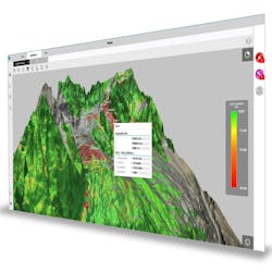
The system combines seamless data ingestion, collaborative analysis tools, and automated intelligent alerts. By offering a consolidated view of displacement patterns, correlations, and anomalies, the platform aims to make insights more accessible to both specialists and non-experts, supporting faster and more informed decisions.
GeoMonitoring includes updated IT security features such as encrypted data transmission, protected user access, and multi-user profiles, allowing multiple stakeholders to operate within the same secure project environment.
“GeoMonitoring is a growing platform built with users at the core,” said Niccolò Coli, president of Radar & Monitoring at Hexagon’s Geosystems division, in a statement. “With its scalable software architecture, GeoMonitoring supports diverse projects from local site to large-scale multi-site monitorings. Users can collaborate across workflows and benefit from optimised radar data management with leaner processes, advanced alarms management, and fast access to data.”
--This piece was created with the assistance of generative AI tools and was edited by our content team for clarity and accuracy.