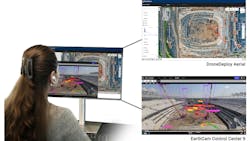
EarthCam and DroneDeploy Integration Adds Live Streaming
A new integration between EarthCam’s Control Center SaaS and DroneDeploy’s unified reality capture platform combines live-streaming video, gigapixel time-lapse archives, orthomosaic maps, and 360-degree site documentation.
EarthCam’s AI-powered analytics interacts with the data to provide automated insights into progress, assets, and equipment across their projects, according to EarthCam.
Read today’s top news.
“By combining DroneDeploy’s imagery with EarthCam’s live content, users gain a valuable, multi-perspective view of their job site productivity,” said Brian Cury, CEO and founder of EarthCam, in a statement. “This unified perspective ensures every event is captured, from detailed archived aerial photos to live views, for continuous progress monitoring, safety and security.”
Stated Grant Barton, CM-BIM VDC engineer at the Tennessee Builders Alliance, constructing the new stadium for the Tennessee Titans:
“The integration is about connecting the dots between what’s captured in the air and what’s happening on the ground. It’s helped improve coordination and accountability across our teams.”
The use of aerial and ground imagery allows users to consolidate views into a single pane of glass, accessible from either EarthCam’s Control Center or DroneDeploy Aerial. The two-way data flow enables automatic synchronization and real-time updates.
“Our customers want all their data in one place,” said Mike Winn, CEO and co-founder of DroneDeploy, in a statement. “Combining visual data from fixed cameras with drone and handheld camera imagery democratizes data across the workforce, enabling better decision making on all their projects. The integration of EarthCam’s imagery expands our platform’s existing air and ground viewports, delivering the most complete reality capture experience available.”
Because DroneDeploy’s aerial data synchronizes to EarthCam’s Control Center 9 in real time, the system provides seamless documentation and earlier issue detection. Users can view EarthCam’s live streams, panoramas, and time-lapse imagery within DroneDeploy, and DroneDeploy’s orthomosaics and 360-degree captures appear inside EarthCam’s Control Center 9.
A simple setup process enables teams to quickly combine aerial and live ground-level visual data across both systems, minimizing configuration time and improving efficiencies in tracking and reporting, according to the companies.
