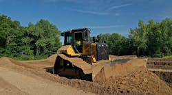
A machine-control system begins with a base station, consisting of a receiver, antenna, radio and power source. The rover receiver is mounted in the machine, and an antenna (or pair of antennas) is mounted to the machine's cutting edge (except excavators) and linked to the receiver via cables.
A computerized controller in the machine cab accepts the job-plan data card and compares location information from the rover receiver with grade information. The system then displays this information on an interactive in-cab monitor. If the system is to be "automated" (capable of automatically controlling the machine's cutting edge), then an "interface" is installed between the system's electronics and the machine's hydraulics.
You can expect to pay between $85,000 and $110,000, depending on options, for installing an automated system, including the base station. Additional machines working on the same site, however, use the same base station, so you can subtract around $25,000 from their system-installation cost. Not installing the electronic/hydraulic interface (making the system an "indicate-only" type) can save another $7,000 to $10,000.
Nearly all GPS systems for dozers and motor graders are sold with the electronic/hydraulic interface, while scrapers and compactors may or may not be so equipped. Excavators, by virtue of the work they do, don't use the interface. If a dozer or a motor grader with an automated GPS system is hogging dirt, the operator usually switches off the interface and uses the system in its indicate-only mode. As final grade approaches, the automatic system is switched on.
If your present machine is equipped with a laser- or sonic-based grade-control system, your costs for adding GPS can be reduced, because, frequently, major components in the system work with multiple-sensor inputs. You may even consider retaining the present grade-control system and "overlaying" it, so to speak, with GPS. It's a way to further improve the accuracy of your machine across a wider range of grading situations.
A typical grade-management system, which, again, offers such capabilities as grade checking, point location and topographical surveying, consists of a base station and a hand-held or range-pole-mounted rover receiver with a built-in display screen. These systems vary in price, but are available in the range of $30,000 to $40,000.
Digital terrain modelsIn conventional earthmoving, the correctness of the final grade is only as good as the information on the grade stakes. Likewise, with GPS machine-control, the final grade is only as good as the information in the DTM (digital terrain model)—that electronic, 3-D representation of the site.
In most instances, the developer or engineer delivers job plans to the contractor in an electronic, computer-assisted-design (CAD) file. Often, the CAD file is created in a two-dimensional (2-D) format, which must be converted to a 3-D format for constructing the DTM. Help for creating the DTM typically is available from GPS dealers, and in some instances, from civil engineering firms.
Contractors choosing to create their own DTMs, however, can use conversion software available from GPS suppliers and from software specialists, some of whom offer training for their products. Contractors who build their own models cite savings in time and expense, plus better control, as their motives.
"We do all our models in-house," says Rob Mills, project engineer for Teichert Construction Co.'s Lincoln (Calif.) branch. "This works best for us, because the developer is always pushing to get the project underway. There are also usually numerous changes during the course of the job, and if we relied on an outside source, we'd lose time transferring information back and forth. Plus, we can customize the model as we build it, like including particular lines that a foreman wants depicted."
According to Don Ahmer (Read Excavating), his company elected to bring DTMs in-house because of economics.
"The modeling software was pricey," he says, "but we figure it paid for itself in a year by our not having to pay someone else to do the job. We get an electronic CAD file by e-mail or on a disc, then we export the data into Agtek Earthwork 3D. You don't have to digitize, just pull the contours over. You then have to put it into, say, a Topcon or Trimble format by changing the file extension."
Like Ahmer, project manager for Nyen Excavating, Jenny Nyen uses Agtek Earthwork 3D to convert CAD files supplied by the engineer. She agrees with Ahmer that not having to digitize is a time saver, which, she says, hastens the payback of the software investment.
"Engineers were skeptical of our modeling at first," says Nyen, "because they thought our 3-D conversion would distort their plan. I had to show them that I wasn't altering any of their lines. It took a while to win their confidence, but now they seem actually grateful that we have this capability. It serves as a double check on the plan."
To expediently handle any glitches in the DTM, Ahmer has loaded a powerful laptop computer and an all-terrain vehicle into a van. If an operator reports a possible DTM problem, the troubleshooter drives to the site (using the ATV to reach the machine if necessary), pulls the data card, and uses the laptop to make the fix. The laptop stores all current DTMs, so if the troubleshooter is occupied elsewhere, he can display the suspect DTM on the laptop and converse with the operator by phone.
"You have to support these systems if you want full value from them," says Ahmer. "You can't dabble. You have to jump in and support them."