Baidu Links Terrain Mapping to Autonomy
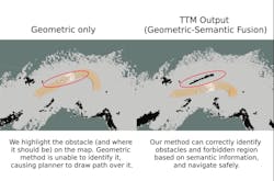
Baidu has developed Terrain Traversability Mapping (TTM), a real-time system for estimating terrain traversability and planning paths for autonomous excavators in “unstructured” environments.
The company defines "unstructured” as a terrain that lacks structure and has unpredictable and potentially hazardous conditions.
“Such an environment lacks any lane markings and the arrangement of obstacles tends to be non-uniform,” according to its paper describing TTM. “Due to tasks like digging and dumping, the working conditions for excavators are constantly changing. In addition, landfalls and cave-ins might happen, which might cause the excavator to tip over and injure the operator.”
The mapping system works in conjunction with its autonomous excavator system (AES). Using both 2D and 3D mapping technologies including LiDAR and excavator-mounted cameras, Baidu will use field robots to generate a traversability map. It will take a 3D pointcloud stream from the LiDAR, an RGB camera stream from the excavator cameras, and the corresponding poses of the excavator extracted from the GPS-RTK module.
The output of the method, according to Baidu, is a global map consisting of terrain information, including semantic information, geometric information, and a final traversability score.
Baidu is working in partnership with the University of Maryland, College Park. They produced the video below.
Source: Baidu
