Marty Savko Jr. is a member of our 2013 class of Under 40 in Construction Equipment. One of the reasons we chose him was because he introduced machine control into his company, Nickolas Savko & Sons.
In our profile of Savko, he told how he brought the idea of GPS machine control to his dad. “I was able to show him that instead of pounding hundreds of stakes into the ground, with GPS we could go out and do 800 acres, move dirt, and pave with no stakes.”
Two years later, Savko continues to build on this model of machine control. I visited Columbus, Ohio, where Savko is headquartered, and he showed me two ways he is working to improve earthmoving production using machine control.
His first idea eliminates the need, he says, to set up and take down the base station for a project. He built a permanent base station that can be moved from project to project (see image at bottom) and allows the hardware to stay firmly mounted at a consistent height atop a tower high enough to allow access from any GPS unit on the project. A solar panel powers the unit, and a lockbox keeps the technology safe when not in use.
The concrete base has hooks, which enable it to be moved, and the tower folds to allow for compact transport to the next job.
Savko’s second improvement is integration of a drone into the company’s bidding process. Cost per cubic yard is the key to any earthmoving bid, and the topographical surveys (topos) provided by engineering firms are notoriously inaccurate, he says.
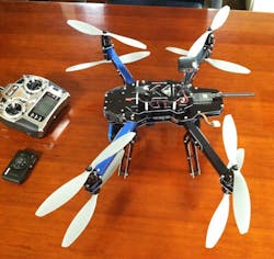
He purchased an X8-M unit from 3D Robotics and mounted a camera to its belly. GPS sensors in the drone and in the camera allow the company to create its own topo with accuracy within a couple of centimeters, Savko says.
The drone flies at about 60 meters, can cover 25 acres on one 14-minute battery pack, and takes about 300 images during that flight. In addition, the drone captures positioning data that not only limits the need for stakes, but also gives the estimator more than 10 times as many points of reference as a staked survey would provide.
Once back in the estimating department, images are downloaded and processed, which takes between 8 and 18 hours. With that map, the estimating department can more accurately build its bid.
The drone retails for around $5,000 plus software. The company purchased it from a local dealer, Savko says, because he wanted local support.
The video below shows how the drone is assembled.
This article has been updated.
