US Radar Seeker Acquisition Software Updated to Version 5.0
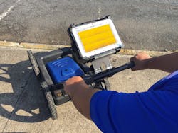
US Radar, a manufacturer of subsurface imaging systems, has introduced Version 5.0 of its Seeker acquisition software, designed to automate several key capabilities for increasing the accuracy of its ground-penetrating radar (GPR) systems.
According to the company, the new software “adjusts the gain of the radar signal to enhance underground target identification and layer tracing.” Seeker 5.0 also automatically recognizes and confirms the GPR system’s antenna and configures antenna-specific settings, such as depth range and encoder interval.
“By automating the most important settings, we’ve made Seeker 5.0 much easier to use accurately and productively,” says Matt Keys, US Radar systems engineer. “Correctly setting the gain level takes experience, especially continuing to adjust it while using the GPR system. Automatic gain control is especially helpful in simplifying and streamlining the process for operators of any level of expertise, but an override capability enables experienced operators to manually set gain levels.”
Without the new automatic antenna-setting feature, says the company, the operator must know which antenna the system is using and then manually enter the settings to enable the use of the specific antenna model. The new software takes the guesswork out of this process, says US Radar, by automatically recognizing the antenna and accurately establishing all the proper settings, reducing the potential for errors.
In addition to automatic gain-control and antenna set-up capabilities, the new software also offers soil-condition calibration, geopositioning and backtracking, data recording and storage, distance measurement, and the capability to highlight and annotate specific locations, positions, and depths. Seeker software is compatible with a wide variety of complementary software applications, says the company, including 3D rendering, image processing, topography and mapping, animation, data filtering, and various data importing and exporting utilities.
Further enhancement of US Radar GPR systems includes what the company calls a “major upgrade of the global-positioning system (GPS) software module and the integration of Garmin GPS technology into the company’s most popular systems.”
The company’s GPS software now incorporates a split-screen view that can simultaneously display real-time, radar-mapped imagery of the job site alongside the user’s choice of maps from both public and proprietary mapping sources, including site plans or as-built plans. The split-screen capability is designed “to provide enhanced, real-time context for plotting and analyzing subsurface data,” says the company. Operators also can combine radar and map data and export it into AutoCAD or ArcGIS software while on the job site.